
|

Pushkov Institute of Terrestrial Magnetism, Ionosphere and Radio Wave Propagation Russian Academy of Sciences ( founded in 1939 ) |

|
| Language [RU/EN] |
| Home | UP | Research | Projects | Services | Info | News | Events | Personal | Archive |
|
The dependence of the main ionospheric trough shape on longitude, altitude, season, local time, and solar and magnetic activityA. T. KarpachevInstitute of Terrestrial Magnetism, Ionosphere, and Radiowave Propagation, Russian Academy of Sciences, Troitsk, Moscow region, 142190 Russia e-mail: karp@izmiran.ru Pages: 1 | 2 | 3 | 4 | 5 Apparently, the influence of solar activity on the MIT shape was studied most thoroughly by Besprozvannaya [1975]. In so doing, she used ground-based sounding data obtained in the Northern Hemisphere at 0200 LT. She indicated that, at a solar activity minimum, MIT exists even in summer in the Western Hemisphere, whereas it is not formed in May-August at a solar activity maximum. The trough is much more pronounced in winter at a minimum of solar activity. Both walls of MIT are equally steep at a solar activity minimum, and, at a maximum, the equatorial wall becomes so declivous that the MIT width becomes indefinite. Now we consider the MIT shape variations according to Cosmos-900 satellite data. For this purpose, we will average data for the equinoctial conditions of low (F10.7 ~ 90) and high (F10.7 ~ 180) solar activity. We consider the most typical longitudes (300-330o and 210-240o) in the Northern Hemisphere (Fig. 7). Figure 7 shows that the Ne latitudinal profiles in both longitudinal sectors are similar at high and low solar activity. However, the Ne decrease at increasing solar activity is slightly larger at a trough minimum; therefore, the trough depth increases from ~1.6 to 2.5 at longitudes of 300-330o. As was shown above, at longitudes of 210-240o in the Northern Hemisphere, the trough is insignificant at high solar activity; therefore, its depth increases here even more considerably: from ~1.5 to 5. At the same time, the MIT width increases insignificantly: from 9o to 10o and from 10o to 12o at longitudes of 300-330o and 210-240o, respectively. As a result, at low solar activity, both walls of the trough become almost equally steep, which confirms the conclusion drawn by Besprozvannaya [1975]. 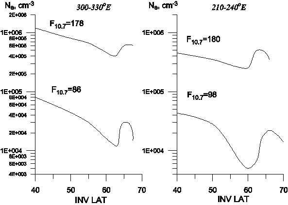
Thus, the trough shape considerably depends on the illumination degree of the ionosphere. At low illumination (at low solar activity during winter nights), both walls of MIT are as a rule pronounced and the trough is deep and very narrow. At a very high solar activity, only the polar wall, clearly defined at heights of the F2 layer, testifies to the presence of MIT even under winter conditions. Under summer conditions at high solar activity, the MIT is formed only at isolated longitudes at a minimum of the background concentration. MIT is not formed under quiet summer conditions. It is most convenient to study the altitudinal variation in the MIT shape using data of topside sounding. Therefore, these studies are mainly based on Alouett, ISIS, and Intercosmos-19 data (see, e.g., Mendillo and Chacko [1977]). Ben'kova et al. [1993] analyzed rather thoroughly the MIT shape variations at high solar activity using Intercosmos-19 data. Therefore, we consider only two MIT examples typical of this period (see Fig. 8). Data were obtained onboard the Intercosmos-19 satellite during the topside sounding over Moscow on September 30, 1980, and March 18, 1981. In these cases the geophysical conditions were similar: F10.7 ~ 180, 0330 and 0430 LT at latitudes of a MIT minimum, a satellite height of 750 and 580 km, and Kp = 2+ and 2o, respectively. Although data correspond to the autumnal and vernal equinoxes, MIT is pronounced in both cases: its depth is ~3 (Fig. 8a) and ~2 (Fig. 8b) relative to the point of inflection on the equatorial wall at the F2 layer height. Under quiet and moderately disturbed conditions, the trough depth can first increase relative to the equatorial wall with increasing altitude [Ben'kova et al., 1993]. Figure 8b shows that the MIT depth is ~2.5 at a height of 580 km. However, at higher altitudes the MIT depth is always less than at the F2 layer height [Ben'kova et al., 1993]. For example, the MIT depth decreased from ~3 to ~1.8 with altitude increasing from hmF2 to 750 km (Fig. 8a). The MIT depth determined relative to the peak of the MIT polar wall undergoes more complicated altitude variations [Ben'kova et al., 1993], which is evident in Fig. 8. In the first case (Fig. 8a), the relative value of the MIT polar wall increased with increasing altitude, and so the MIT depth also increased from ~3 to ~5. In the second case (Fig. 8b), on the contrary, the value of the polar wall decreased with increasing altitude, and the MIT depth correspondingly decreased from ~2.5 to ~2. 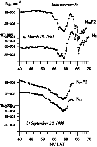
Ben'kova et al. [1993] stated that at low solar activity the trough depth relative to the
peaks of both MIT walls increases sharply with altitude increasing from hmF2 to ~900 km.
We will verify this confirmation. For this purpose, we consider data of topside sounding
onboard the Cosmos-1809 satellite [Deminov et al., 1992] and simultaneous observations of the
equatorial boundary of the auroral particle diffuse precipitations (DPB), performed onboard
the DMSP satellite [Szuszczewicz et al., 1993] in May-June 1987 in the Southern (winter)
Hemisphere. Data of both satellites correspond to the post-midnight hours (0200-0400 LT).
The period considered was characterized by low solar activity
(F10.7 = 70) and increased magnetic activity. Thus, a
prolonged disturbance of the geomagnetic field was observed from May 25 to June 2. This
disturbance included the series of storms with maximal intensities of Kp = 5, 4, 5-, 4-,
and 3+ on May, 25, 27, 29, and 31 and on June 2, respectively. We take the end of this
series of storms (June 2, ~1200 UT) as t = 0. The period from June 2 to June 5 (t > 0)
was characterized by low activity (Kp < 2). Data of three Cosmos-1809 orbits fall into
this relatively quiet period (Kp = 1-, 1+, and 2-). They are marked by successive numbers
1, 2, 3 in Fig. 9 and correspond to t = 0.7, 1.8, and 2.9 days, respectively. One more storm
with Kp = 5 occurred on June 7-8. We designate the end of this storm (June 8, ~0600 UT)
as t* = 0. Orbit 4 corresponds to a very quiet period after this storm (Kp = 0+) with t =
6.6 days and t* = 0.8 days.
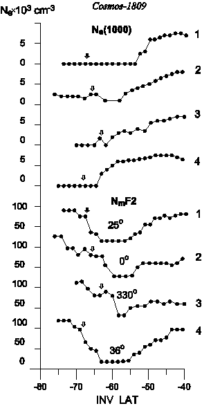
The top and bottom curves in Fig. 9 show the latitude variations in the electron concentration at the satellite height Ne(1000) and NmF2, respectively. The arrows mark the position of DPB. The geographic longitudes are shown for a latitude of  = 60. = 60.
Figure 9 indicates that the pronounced trough is observed at heights of the F2 layer maximum in all cases. The flat bottom of the trough makes it possible to distinguish clearly the bases of both walls of the trough. The polar wall is related to the precipitation, and so the DPB equatorward shift with increasing Kp (especially pronounced for orbit 3) leads to the corresponding shift of its base. The polar wall becomes steeper near its base, but the latitudinal distance from it to DPB vary slightly and is about 5. In this case the orbit-to-orbit variations in the electron concentration at a trough minimum (NmF2x10-4 = 1.5, 3, 3, and 2 cm-3) correlate with the NmF2 variations near a peak of the polar wall (NmF2x10-4 = 8, 10, 11, and 10 cm-3, respectively, at a latitude of 70o). The equatorial wall is more declivous. Its base is located near a latitude of 55o and is slightly shifted
poleward depending on the time t that elapsed after the previous storm. The electron
concentration variations at midlatitudes
(NmF2x10-4 = 9, 7.5, 6.5, and 9.5
cm-3 at a latitude of
40o for orbits 1, 2, 3, and 4, respectively) are depends on
the longitudinal effect, which shows that the NmF2 concentration at the trough bottom has
the lowest values in the considered longitude interval
(30oW - 40oE). A weak
variability of NmF2 at the trough bottom in this longitude interval is apparently related
to a specific saturation effect, when the sunlit conjugate ionosphere prevents from a
decrease in the mean value of the electron concentration below some limiting level (NmF2).
It follows from data shown in Fig. 9 and obtained by Deminov and Karpachev [1988] for high
solar activity that (NmF2) ~ 2x10⁴ and
4x104 cm-3 for near-midnight
hours during local winter at F10.7 ~ 70 and 200, respectively.
Thus, the NmF2 variations at the trough bottom are determined by LE and magnetic activity.
Last page » |


|
(C) 2007, IZMIRAN
|